Lee's Ferry, River Mile 0. Photo Sam Reese.
My brother buttoned his shirt off kilter and it stayed that way for three days. Nobody told him, including me. It’s likely I saw the misbuttoning but it didn’t register on my mental radar. Some of our rafting group noticed but didn’t tell him. How is the buttoning of a shirt relevant on a Grand Canyon raft trip lasting 18 days? Sam wore a nice shirt, long sleeves, and light blue with a collar. Prior to the trip he probably wore to business meetings. I brought a similar shirt and I wore it to business meetings pre-trip. Neither of us got a sun burn. For all I know, I misbuttoned my own shirt and nobody ever told me. I couldn’t know now even if I asked my expedition mates because they might not have noticed and wouldn’t remember now if they had.
Things like that don’t matter on the river. I am only aware that I didn’t misbutton my own shirt for three days because I slept in a different shirt than I wore all day. I may have misbuttoned but not for three days in a row. Sam had nobody to impress and my impressions were easy. I was sleeping with my wife on this trip and Sam’s wife stayed in Portland. All I had to do was wear a different shirt to bed than I wore all day and my wife thought I was the man of the year. This trip celebrated our thirtieth anniversary. Evonne commented after the trip that one of the high points of the trip was the lack of mirrors. With time away from a mirror, you don’t give a flying fuck about things as superficial as shirt buttoning, wrinkles on your face, brand names, socio-economic status, education level, ethnic background, religious affiliation, or the morality of using phrases like “flying fuck.” A week after coming off the river the world feels obscene for the fact that people do care about that sort of thing and it feels obscene because I know that my river high will wear off and I will again care about evil things like that. I spent all day yesterday looking out of my office window, knowing that everybody in my building was kissing up to management so they could buy a nicer car than the next person’s car, knowing that management doesn’t care enough about us to ensure we get a place to park that car. Some of those concerns are evil too and that is one of the reasons that we need wild places.
Globemallow. Photo by Sam Reese

A week after getting home I am having a tough time getting back to life as I used to live it. People hate each other over stuff that seems so stupid when seen through river eyes. My values don’t fit American life. Work seems stupid not because I don’t believe in hard work but because I am not sure most people’s work makes the world a better place or that my work is making me happier or those I love happier. I pay bills to a shitty bank, owned by bankers that are parasites. Yet, the bankers themselves are often depressed more than the people working their asses off to pay for their yachts. It wasn’t the Grand Canyon that created my view of the world; it was the Grand Canyon that allowed me to see it clearly. In a few months I will have largely pushed these thoughts out of my head, will place my nose back on the grindstone, and will act just fine except for the cognitive dissonance I get from ignoring my belief that that only way to win a race on a treadmill is to step off of it.
 Dean, Carl (me), Syd, Jess, Aubrey, Celeste, Sam. Starting Crew.
There were eight people in our group starting out: Dean, Sam, Sydney, Evonne, Aubrey, Celeste, Jess, and me. Aubrey and Celeste planned to hike out at Phantom Ranch, river mile 89, after a week on the river. Celeste had to leave our trip before she planned. At Phantom Ranch Pete and David hiked down and rafted the rest of the river. Evonne is my wife, Dean and Sam are my brothers, Aubrey and Sydney are our grown daughters, Celeste is Evonne’s sister, Pete is my friend and long time climbing partner, and Jess is our friend from Juneau. We had four rafts for eight people and our boat operators were Dean, Sam, Jess, and me. Though we had oared many rapids in the canyon before, this was the first time Sam or I had been the responsible for a raft and the safe passage of passengers on the raft.
The canyon trip went remarkably well. Sam’s three day misbutton period was part of a period of six days of cold rainy weather. Sam removed his shirt to swim in the river and creeks in the side canyons when it was hot out but we all stayed glued to as many layers as we owned when it was cold. The first week of our trip was cold and felt like October in Juneau and January in Portland, not Arizona late April.
Aubrey at Nankoweap.
I think there are two general categories of mistakes on expeditions, those you can plan for and those you cannot. Suppose you slip into a creek on a winter mountaineering trip, you get your feet wet in ice water, and you frostbite your toes. You made a mistake in stepping in the water; it is true. However, it could also be said that the biggest mistake and the only correctable mistake occurred before the trip when you forgot to pack a spare dry pair of socks. It’s poor judgment to ignore that people can slip into water, that wet feet can lead to frostbite, and that a pair of socks can save toes. It’s impossible to keep a goal to never slip. It’s the before trip mistake that you can most easily avoid. These types of errors are not always some item one forgets to bring (like dry socks), but often that you brought too much stuff. I made several unavoidable mistakes and two that I could have been able to avoid, fortunately without dire consequences.
Before you throw hammers at me for my mistakes, everybody makes both of these types of mistakes and this trip had fewer than most. It’s folly for any trip planner to think they don’t or can’t make avoidable mistakes. I think that it’s in self doubt that we find our own errors. I am wary of anyone that says they know they are right with too much fervor. Preachers don’t really know that God exists even though they prattle on about their surety. Atheists don’t really know that God does not exist either. Conversely, the person that says they don’t or can’t misjudge a river can’t be entirely trusted.
Gear Pile At Lee's Ferry.
The warehouse contained rafts, oars, coolers, ammunition cans, aluminum frames, and hodgepodge mix of other river gear that we rented for the trip. The warehouse rests in a mostly ugly slice of earth near the Flagstaff Mall. There are strip mined hills to the east and north. To the south Interstate 40 blares by. The ugly is balanced by the view to the west. The San Francisco Peaks rise thousands of feet above Flagstaff. Snow was forecasted on the San Francisco Peaks on April 25th, the day we met at Moenkopi’s warehouse to gear up. Indeed it snowed later that day but we were in Lee’s Ferry by then. However, missing the snow storm didn’t mean we missed the cold. We spent the afternoon at Lee’s Ferry rigging our boats in a cold wind.
The weather was yet another miscalculation and that miscalculation mostly was my fault. Climate statistics suggest that a trip like this should expect warm to hot weather and that it might be little chilly in the morning. Rain is very rare this time of year most years. However, once every few years it’s cold and rainy and it sucks to be on the river in those conditions without appropriate clothing. The first week of our trip had some chilly experiences. I brought four tee shirts but didn’t bring a rain jacket. Other folks had similar problems of bringing too much of stuff they didn’t need and not enough stuff they did need.
April 25. Day 1. Starting at Mile 0. Rigging up was indeed a stressful event, especially for those who hadn’t experienced it before. Lee’s Ferry is oft called Lees Ferry sans the apostrophe. I am not positive of how they lost the apostrophe but its loss created distance between the locale and John D. Lee, a notorious mass murderer who established Lee’s Ferry in the 19th century. Nobody was murdered there on rig day and we got our boats rigged up in time to enjoy a nice dinner at the Marble Canyon Lodge. The term Marble Canyon a name invented whole cloth to justify a dam. The Bureau of Reclamation tried to rename the upper forty miles of the Grand Canyon so they could claim a proposed dam wasn’t flooding the Grand Canyon. The dam was never built. The Grand Canyon starts at Lee’s. From Lee’s Ferry the river dives into a canyon that does not abate until the Grand Wash Cliffs 270 miles downstream.
Splash off a wave. Photo was by Pete Boyd.
I have no pics of water because my camera isn't waterproof.

The morning following rig day we suffered through a river orientation delivered by a National Park Service Ranger who clearly hates public speaking and has zero public speaking skills. After snoozing through his hour long speech, we hit the river around11AM and had an enjoyable day except for the fact that I ran my raft sideways into the hole at the top of Badger Rapid. Tom Martin’s Guide to the Colorado River in the Grand Canyon says Badger Rapid is the first significant rapid in the canyon but few people take Tom seriously about Badger. I was thrown across the raft and nearly fell out. IN BADGER! I call this my Badger mistake and I don’t think I could have avoided it without a crystal ball. You can’t scout all rapids and any reminder that you have to be extra alert at all times misses the meaning of the word extra. I am sort of glad I hit that hole because it was a reminder down the river that it’s easy to become cavalier about rapids. Badger is very rarely a problem because that hole is really easy to miss but you hit it, you know you hit it.
One of the banes of our trip was the phrase, “Have you seen the ______.” Fill in the blank with anything. We got hit with unseasonably cold weather for the first week and shivered a lot but it wasn’t as frustrating to me as not being able to find essentials for day to day life.
Which dry bag did we put the sleeping bags?
Hell if I know.
 Layers in the Redwall
Conversations like this often led to arguments with Evonne about who was responsible for the misplaced sleeping bags, tooth brushes, or endless amounts of whatnot. The argument would end in embarrassment when we found the misplaced items in what would in hindsight seems a great place to put them. Toward the end of the trip, we had a system. We also brought way too much stuff and I should have known to cull things down. Yet, I saw packing from the perspective of the available room for gear in the rafts. The rafts have lots of room; why not bring lots of stuff? Indeed our rafts did have a lot of space but that doesn’t change that the more gear you carry to more stuff you can misplace.
If this trip were a concerto, the overture began in Flagstaff, Arizona at a warehouse in an industrial park on April 25. It was a beautiful trip and music is the great metaphor for how it played out. We missed beats and buzzed notes quite often but overall the trip seared into my consciousness like a concerto in the most beautiful way. Buzzed notes make music human and it’s the humanness of music that makes it worth hearing. Do songbirds ever miss a beat? Hell if know.
We camped that night at Soap Creek.
Day 2. Starting at Mile 11. Soap Creek. We got off the river late and headed down river and camped that night at North Canyon.
North Canyon photo by Sam Reese.
Photo Sam Reese
In the evening we took a short hike up North Canyon. It’s a great short hike with beautiful flowers and a large willow in the middle of the stream bed. That night we got hit with our first real thunderstorm.
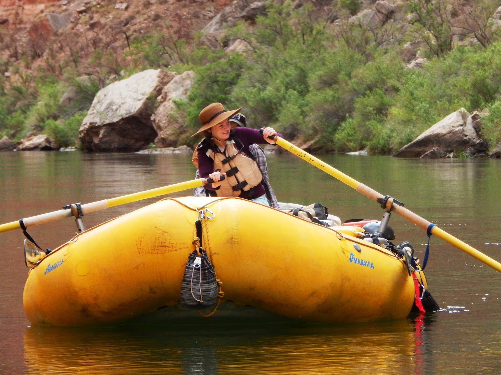
Sydney at the oars.
Day 3, RM 21. It rained sporadically through the morning. Remarkably, the rain stopped right before we got to the Redwall Cavern at river mile 32. Also incredible, was the fact that no other trips stopped at the Redwall Cavern while we were there.
Lunch at Redwall Cavern

The Redwall Cavern is a magical place to me even among the other places in the Grand Canyon. This particular trip felt even better due to a vain hope that we might actually finish this trip without shivering for very long time. Like most places in the canyon, the Redwall Cavern shows little sign that people visit even though dozens visit every day. There is no litter. There are no fire pits. It’s illegal to camp there. There is nothing but foot prints in the sand to indicate the human race exists at all. The cavern itself isn’t a cave like a spelunker might crawl through but a massive alcove in the rock just above water. It is bigger than the Hollywood dome, large enough for a full soccer game, and tall enough that you can’t hit the ceiling with a Frisbee. We tried. Sunlight from the river reflected on the ceiling, creating a dance of light not unlike the Northern Lights. We sat in the sun with our feet in the hot sand, collecting heat like chuckwallas. It is my thought that three hours of sunshine at the Redwall Cavern largely saved the trip for Aubrey because it was a perfect moment in a long stretch of cold. I did some bouldering using the soft sand as a “crash pad.” I didn’t climb rocks much on this trip but the climbing I did was some of the most aesthetic climbing I have ever done.
Sam playing guitar at Redwall Cavern.
The Redwall Cavern is a marvelous place to climb rocks. Boulder problems abound, varying in difficulty from V1 to Vhard. I found a boulder problem that suited my skill level and eventually completed it before ripping a small chunk of skin off my index finger. I should have taped up first. Though the Redwall Cavern is great place to climb, most people do not go there to climb and it seems that climbers should be aware of other people’s concerns. Non climbers have complained in the past about chalk on the walls and I think the complaint is justified considering there are no other real signs of human impact. Also, unlike most other places in the canyon it never rains inside the Redwall Cavern because it is a large overhang. Chalk will never wash off. I dried my hands on my cotton shorts sans chalk.
Evonne. Redwall Cavern

We continued down river and camped at Nautiloid. Nautiloid has amazing views up and down a very tight closed in canyon with a lot of caves and springs. It also has fossils of nautili.
Day 4, Starting at Mile 35.We awoke to cloudy skies at Nautiloid and made our way down river and got to our camp at Nankoweap early afternoon. The sun came out and we had a great hike up to some Anasazi granaries about 900 feet above the river. Nankoweap has a wide open canyon and you can easily envision communities living along the river, fishing and growing crops.
Nautilus Fossil embedded. they show up
better when you pour water on the rock.

The Anasazi that built the granaries at Nankoweap lived in a very different world than what we see now. The Colorado River was once full of fish that are close to extinct. The Colorado pikeminnow once thrived and grew to six feet long in the canyon and they are now gone except for remnant populations in many hundreds of miles up river. I know their story in part because I wrote my Masters Thesis on the interaction of trout and pikeminnows. More people read this blog than will ever read my thesis. The demise of the Colorado pikeminnow and other native fishes is tied to massive changes in hydrology due to Glen Canyon Dam upriver. Prior to the dam the river raged big and muddy in spring when the snow in the Utah, Wyoming, and Colorado melted. Flows trickled to low enough to wade the river in the summer and water temperatures were warm enough to kill trout. Nowadays, spring snow melt is caught behind the dam and dam releases are cold all year. Trout out competed and ate the native fish. Eating another species is the most aggressive form of interspecies competition. Biology lesson is now over. The Colorado River in the Grand Canyon looks pristine but the river itself is the one aspect of the canyon that is radically altered.
Aubrey and Sydney at Nankoweap.
Other aspects of the Grand Canyon are much, much less altered. The NPS provided us with 31 pages of obtuse regulations. For example they take several pages to say, “Don’t pee in camp.” However legalese the regs are, the ideas behind the regs credit the National Park Service. Litter is so rare along the river that I can’t recall seeing it. Each camp has thousands camping every year and yet there is no sign of a fire pit at any of the camps. The trails are clean. Regulations say you should haul out your poop and it seems everybody does so because you don’t see shit anywhere.
Day 5. Starting at Mile 52. In the morning moods were not good. We set up shade umbrellas around the kitchen and that helped but still the rain kept falling. Yes, we were all humming, “Who will stop the rain.” Nobody stopped it though; not even Credence. We headed downriver in a down pour because often the best way to stay warm is to keep moving. That worked to a degree but by the time we reached the confluence with the Little Colorado River it was pouring and it felt like Juneau in October or Portland in January. None of the Juneau or Portland members of our group were pleased and neither was our one Arizona member. We shivered a lot that afternoon.
Camp at Nankoweap in the morning.
The Little Colorado River was running brilliantly turquoise despite the rainstorm. The color of the water seemed to jump out among the dark colors of the storm. I might have appreciated the beauty more, had I not been so cold. Though the Little Colorado was dazzlingly beautiful, we didn’t linger long and we made our way to Tanner Camp by early afternoon. Fortunately, the rain broke and the sun came out in riot force as we pulled into Tanner Camp. Once again we sucked up the sun like chuckwallas. The sun lasted just long enough for us to set up camp and take a short hike. The hike at Tanner goes to some pictographs that we didn’t find and gave up looking for because the rain was coming soon. The rain arrived and pelted down heavy but fortunately, we had a nice tarp up. We huddled under the tarp playing poker with M&Ms and drinking whisky into the evening.
Chuckwalla sunning itself.
Day 6. Starting at Mile 68. We got up early and started early from Tanner Camp. This is where we encountered our first rapid of major concern. Hance Rapid is the only rapid upstream of Phantom Ranch that that shakes your bones. Sockdolager is also big but not like Hance. Sockdolager is an archaic term for a knockout punch in boxing but despite its name we didn’t scout it out. We scouted Hance Rapid, made some decisions, and went down. In truth I think my screwup at Badger put me on my toes at Hance Rapid.
Jess fell out of the boat in a hole mid rapid. Fortunately, she was able to get back to the raft and Evonne was able to pull her back aboard before the last fairly heinous holes in Hance. Evonne had no experience rowing and was actually scared shitless of big rapids up that moment. I think Jess ejecting from her seat may have been good for Evonne’s morale. The thing that she feared could happen actually did happen and Jess got back in the boat. Sydney wants to petition to National Park Service to change the name of Hance Rapid to something a little more sinister. I doubt she will follow through.
We camped that night at Upper Cremation Camp just upstream of Phantom Ranch near a group of from Wyoming that included some musicians. They stopped by our camp to play some music that night. Their group had a guitar player and a banjo player. Both of them were talented but seemed reluctant to let go. Mostly they chose to follow our leads and apparently we had been shivering long enough that now that it was warm, we let go.
Our group was rich with practiced musicians and that was before David arrived the next day, adding to our little band. There was something about the canyon and our camp and all those people sharing a moment that brought the best in music I think. The “fire” was a lantern sitting in the middle of the circle of chairs. Strange how we stared at it like it was a real fire. At one point I handed a guitar to Sydney, who had been silent up to that point, and she played Sully’s Song and some people actually got out of their chairs to applaud. Standing ovations are rare at campfires even when the “fire” is a lantern. We buzzed more than a few notes but the music sounded awesome.
What will become of my dear friend?
Where will his actions lead us then?
Although I'd like to join the crowd
In their enthusiastic cloud
Try as I may, it doesn't last
And will we ever end up together?
No, I think not, it's never to become
For I am not the one
Dean on mandolin and the banjo player from Wyoming did beautiful duets of some John Prine songs.
Sorry now son but you’re too late in asking.
Mr. Peabody’s coal train hauled it away.
Music is one reason the human race is worth saving.
Day 7. Starting at Mile 86. We left Cremation fairly early and went downriver to Phantom Ranch. Phantom Ranch is the only place in the US where mail is delivered by mule. Aubrey packed her stuff and around ten o’clock headed up the Bright Angel Trail to civilization. Phantom Ranch felt slightly civilized because you can poop without carrying it out, wash your hands in warm water, and purchase stuf from a very limited selection at a small store. That said, Phantom Ranch is not civilization. Right before Aubrey headed uphill, Pete and David came down the hill. We got their gear into the rafts and headed downriver.
As we started out, we saw Aubrey headed up the trail and yelled and waved. She waved back and I was sad to see her go. Aubrey left the canyon one day after the weather cleared. She was so upbeat anyway and great to have along. Aubrey invented the bicycle to keep warm maneuver.
Aubrey demonstrates the bicycle maneuver.
The day downriver from Phantom Ranch has some large rapids, notably Granite, Hermit, and the Horn Creek. We saved Crystal for the morning and camped at Crystal Camp. Crystal Rapid and Lava are the largest most formidable rapids on the river. That and prior to the trip I read the Emerald Mile which focused heavy on several disasters that occurred at Crystal Rapid.
I did not sleep that night, visions of lines through the rapid kept rolling in my mind. I couldn’t stop the mental tapes. I got up to poop three times. Notwithstanding my nerves, Crystal camp has arguably on of the nicest spots on the river for the groover. One sits on the can, and it is an actual can, with in an alcove of Zoroastrian Granite.
Crystal Groover
The groover is the toilet on a river trip. It’s a large ammunition can that once carried artillery shells. It’s called a groover because when people first started using them they sat directly on the can, leaving grooves on your ass. Nowadays, most folks put a toilet seat on top of the ammo can. You set up a hand wash next to the groover with soap and disinfectant. In the morning you secure the lid and carry your shit downriver to the next locale.
Day 8. Starting at Mile 98. After scouting, we all opted for a left run at Crystal and the rapid itself probably took ten seconds. I recall every one of those seconds in a dreamlike way. My run turned out great as did those of the others in our group for the most part. Sam hit the hole at the bottom of the rapid but hit it straight on and Dean hit the wall on left bank at the tail but neither of these created a problem. Notes got buzzed but the song itself sounded great.
David and Sydney, Blacktail Canyon

Below Crystal Rapid there are many miles of flat water and small rapids. Sydney, David, Pete, and Evonne took turns rowing and learned a lot. I fell asleep while drifting and I really needed the sleep. We made some miles that day too. We had planned to camp at Blacktail Canyon but the camp was taken. Blacktail Canyon is a beautiful place and it is also known incredible acoustics. We had planned to haul our guitars, mandolin, and voices up the canyon and wale out some tunes. Because we couldn’t camp at Blacktail we couldn’t spend much time there. We did sing Happy Birthday to the National Park Service and I am sure we were the only people on the globe to do that. We ended up camping a few miles downriver from Blacktail in an overgrown large camp on the left bank. We got to watch two male bighorns for quite some time. This camp was nice though it didn’t seem to have been used much lately. It had big drainage with some springs but we didn’t take much time to explore because we arrived late and were pretty tired.
Sydney with her oars shipped so she can play the guitar.
Day 9. ~Starting at Mile 122. Day 9 was a short day on the water. I buzzed a note and damn near broke a string at Bedrock Rapid. Bedrock Rapid has a huge boulder mid river and if you go right, the rapid is a non event. If you go left, you face a swirling and jumping eddy that can hold a raft for a very long time. I entered too far right and hit a small rock that bounced my raft left. I hit the bedrock island and thankfully bounced to the right and away from the swirling pit of despair. We camped that night on the beach near Stone Creek. That afternoon, the weather turned and the canyon thermostat shot to hot.
As we were setting up camp, we encounter a chuckwalla sunning on a rock. Jess vowed to get a chuckwalla tattoo, though I don’t think she was serious and I won’t hold her to it. Chuckwallas are some of the largest lizards in the US and they remind me of iguanas, though they are not closely related. After watching Chuck for a while, we visited Stone Creek Falls.
Chuckwalla
We all stood for a while in the falls at Stone Creek to much wonder as the water is cool and clean and we were hot and dirty. Dean, Sam, Pete, David, and I went for a hike up Stone Creek Canyon. It’s a long canyon and we ran out of time to see it all.
Stone Creek Falls, Carl and Evonne
Day 10. Starting at Mile 132. We only went four miles on Day 10 because we stopped at Thunder River. We moored just upstream of Tapeats Creek Rapid to hike to Thunder River. Jess didn’t do the Thunder River hike, opting to head down river solo for the day to hang out at a waterfall four miles downstream. This is good because she wasn’t there for our little Vaudeville show using rafts that happened later in the day. Thunder River is a spring of river size blasting out of the North Rim about 3,000 feet above water level that is fantastic to boggle the senses.
Thunder River
As we were walking back down we encountered a group of hikers from a motorized commercial group and toward the tail end of their hiking entourage we met up with a woman wearing a bikini on a hike through the cactus. She wore fashionable shoes that were no doubt the envy of her friends in Los Angeles but looked silly a mile deep in the Grand Canyon. I thought she was pretty until she spoke and her tone exuded complaints and privilege even more readily than sweat. I suspect the LA Times printed a story saying a Grand Canyon trip is a bucket list event and she believed the article, much to her dismay and mine. As we crossed paths she panted, “Is it worth it?” Her tone suggested disdain for outdoorsy types that think places like Thunder River are worth working to see. We answered, “Hell yes!” but left out that her question invites a subjective answer. She didn’t seem the type that enjoys existential questions.
Is anything in life worth it? Hell if I know
Thunder River

Evonne, Deer Creek.

We got back to the river and our three rafts were still moored at the top of Tapeats Creek Rapid. It’s a smallish rapid. We also had an inflatable kayak that Pete was using. Dean got into his raft and for some reason he can’t quite explain, even though he was there, he got sucked to the edge of the river and stuck between two rocks. Worried that Dean’s raft would become so jammed that we couldn’t get it out, Sam hurriedly jumped in his raft with the intent to help. He got stuck on another rock in fast moving but shallow water. Pete, Sydney, David, and I saw all this unfold and ran to try and help. You could run up to these rafts because the problem was the water wasn’t deep enough to float them. I slipped on a rock and fell on my face before I got near them but wasn’t hurt. It’s slippery you know. About the time Pete got to Dean’s boat, he looked back to see his inflatable kayak was missing. It blew off the beach in the wind and had started to float away, unbeknownst to Pete. Evonne grabbed it and clipped it to something onshore. Pete abandoned helping Dean so he could search for his kayak that he thought had drifted downriver unattended. This all took about ten seconds up to this point. I stood up and asked Evonne to stay with my raft so that we would have at least one raft that wasn’t stuck in the river. Sydney and her David were already helping Dean and Sam because they didn’t fall flat on their faces like I had. The lesson here is to rush to help but not too quickly because hurrying can make stuff worse.
Dean's boat stuck between shore and rock on the far side of his boat.
Dean, Pete, Sydney, and David prepare to heave.
Dean's boat is free.
We pried and pulled on two rafts and got Dean’s boat free with help from Pete who finally found the kayak. We got Sam’s boat free only to have it get stuck on another rock. This rock was too far out in the current for anyone to walk out to and Sam was the only person aboard. Now the scene was improving. Dean was drifting down river. We all cheerleaded as Sam jumped up and down on his raft while prying at the rock with the handle of a shade umbrella. By and by Sam’s raft shook loose and we all headed down river to meet up with Jess. We vowed to never speak a word to Jess but I suppose she will read this.
Meanwhile Evonne took photos. We went four miles downriver and camped on river left across from Deer Creek Falls.
Stone Creek Falls
Deer Creek Falls
Day 11. Starting at Mile 136. In the morning we ferried across the Colorado River to Deer Creek Falls. Jess spent much of the previous day at the Deer Creek Patio so she opted to hang out by the river and the falls. Evonne, Pete, and I did a short hike to the Deer Creek Patio and Sydney, David, Sam, and Dean hiked up to the Throne Room and the spring that shoots out of the wall up there. Nobody was up there but them and a small band of backpackers. That and a pink rattlesnake that blocked the trail forcing them to bushwhack through the cactus. It was a beautiful snake that was mostly minding its own business.
We rafted down the Matkat Hotel, hiked up into the canyon and spent the night at the hotel.
Matkat Patio
Day 12. Starting at Mile 149. We left early that morning and made our way to Upset Rapid. At Badger I got into trouble because I tried a maneuver where you row madly backward at the top of the rapid and spin as you enter the tongue. I didn’t spin fast enough or didn’t initiate soon enough and hit the hole sideways. With some reluctance I tried this again at the top of Upset and it worked. There are rocks at the top of Upset on the right that make it hard to make a right run. Using that spin maneuver I broke the lateral waves on the right side of the tongue at the head of the rapid which placed me on river right but downstream of the rocks. The river pulls you left after that but with a good ferry angle I missed the center of the hole at the bottom that gives Upset Rapid its name. It felt great. We made miles the rest of the day and made it to Mohawk Canyon.
That night we got hit by a thunder storm that left 2 inches of rain in a previously empty bucket. The wind howled and the rain poured and I was damn glad the tent held up. Sadly, our tent’s zipper broke the next day but fortunately it never rained again on the trip.
Day 13 and 14. Starting at Mile 172. We laid over at Mohawk Canyon. We slept in a bit. Evonne did some yoga, the first and only time she did that on our trip. There isn’t as much free time on a raft trip as one would think. The logistics of setting up the kitchen, setting up camp, setting the groover, and cooking meals are considerable work and time. Also, it’s cool in the morning and not conducive to yoga and in the afternoon when the temperatures were right, Evonne wanted to sit and talk, drink beer, and/or listen to music in her spare time. Most of our group hiked up Mohawk Canyon. We found a skull of a bighorn sheep up there.
That evening Pete, Sydney, David, and I created the Franken-sauna. It was a mish mash of tarps and parts of a wrecked tent draped over drift wood. We heated rocks on the blaster, a tool otherwise used to heat dishwater and other instances where you want hot water in a hurry.
Rock heating on the blaster.
The Frankensauna was an experiment with marginal success. If I were doing it again I would heat larger rocks. It was nice in there but not quite hot enough for my sauna tastes.
On day 14 we rafted down to the main Whitmore Camp. Along the way stopped at Pumpkin Springs which has an uncanny resemblance to an oversized pumpkin. We also stopped to jump off a cliff into the water at a place that looks like Simba Rock from the Lion King. Unfortunately, Sydney’s cannonball hurt like hell. Perhaps it isn’t a good idea to cannonball from 35 feet up.
Lava Rapid.
Lava Rapid is the stuff of dreams and nightmares. The holes at the head of Lava swallow and flip boats like pancakes. There are holes lower down that can flip boats as well. In addition to being fierce, Lava Rapid is fairly late in a raft trip and every rower must think about it night after night after night after night. I had planned to climb a big rock called Vulcan’s Anvil that sits mid river just upstream of Lava Rapid. It’s a strange looking rock about 50 feet tall. I got close enough to kiss the Anvil and did so because tradition says it’s good luck. Indeed, Vulcan’s Anvil would be easy to climb and maybe next time I will do so. However, this time I just wanted get through Lava Rapid in an upright position and get my mind off visions lingering from my dreams.
We scouted Lava and Dean went first followed by me, then Sam, and then Jess. We all took a right river run and got bounced around a little but made a shining shot through the beast. I eddied out at the bottom and Sydney took the sticks to run Son of Lava, a smaller but bouncy rapid just down river. Son of Lava is infamous because it’s big enough to scatter swimmers and gear nil and yon if the raft flips in Lava. We stopped at the bottom for a shot of tequila at Tequila Beach just downstream of Son of Lava. It’s tradition even though the tequila tasted bad, being at Tequila Beach tasted grand. Sydney did a cannonball.
Pumpkin Springs
Sydney, Pete and I planned to do some over water solo climbing. This too was an experiment. We climbed a little but learned some things. First, over water solos are when you climb over water using water to break your fall, should you do so. The Grand Canyon is a great place for this in many places. There are great granite cliffs near Tapeats and Deer Creek but when we were there, the water was deep brown from the rain so we didn’t know for sure if it was deep enough to buffer a fall. By day 14 the water had cleared but we found another issue. Even in quiet water, it’s tough to hold the raft still enough to wait for the climber. If I were going again on a river with granite cliffs and deep water, I would bring some cams to clip a raft to the wall. As it turns out Pete and I found a nice spot in an eddy and climbed there for a short period. Sydney didn’t climb because her right leg was still stinging.
We camped that night at the main Whitmore camp a few miles downriver from Lava Rapid at RM 188. We all hiked up to some pictographs and then some of us continued up to the rim. The rim at Whitmore is the lowest spot on the rim for many miles. It was a nice hike that passed a large lava/basalt flow that is only about a million years old. Compared to the rest of the canyon, a million years is brand new.
Day 15. Starting at Mile188. We headed downriver and made some miles. We stopped along the way at Indian Camp at RM 206 that has some old Paiute roasting pits and the Bundy Jars. Cliven Bundy’s dad and possibly Cliven himself as a young man left some jars in a cave in the canyon and used them to store food for when they drove cattle to the river. The jars themselves are boring but two things stand out. The Bundy Jars are slightly older than fifty years old so the National Park Service is bound by law to protect them in the same way they protect the ancient Paiute roasting pit nearby and the jars are evidence that the Bundy’s have been trespassing with their cattle on federal land for many decades before Ammon and his buddies invaded the wildlife refuge in Malheur, Oregon a few months ago.
Some other rafter were already camped at Indian Camp so we headed downriver to Granite Park at RM 209. It’s a nice camp and we had a nice hike up a dry wash in the morning.
Day 16. Starting at Mile 209. After a hike up the wash at Granite Park we rafted downriver to a camp on river right just downstream of Diamond Creek.
Day 17. Starting at Mile 226. The river downstream of Diamond Creek has the last rapids on the river. There are some great rapids though. In addition to the Killer Fangs, there are quite a few medium sized rapids that were a lot of fun and a bit tricky, especially since we handed the oars for most of them to Sydney, David, and Pete. They all were rafting pretty well by the lower canyon
The Killer Fangs was exciting. Jess hit the hole at the top and both she and Pete popped from their seats to prevent the raft from capsizing. It looked cool actually. Hitting the hole, however bouncy, placed Jess in perfect line to miss the fangs themselves. Sam’s line was better at the top but he bumped the fangs. Dean and I had great lines but a mile down river I hit a hole without even looking forward. It was there to remind me not to get cocky I suppose.
At the bottom of the Killer Fangs I felt a bit of a twang of sadness. This was the last rapid with enough punch to really mess you up. Sydney and I talked about the possibility that she would oar the Killer Fangs and I basically made her think she wasn’t ready. Maybe she wasn’t.
But we won’t know now if she was ready and maybe she won’t get another chance. Risks are part of life and I should have been more encouraging. I also felt melancholy because I knew we were headed back to land where people mock misbuttoned shirts.
We camped that night at Surprise Creek.
Day 18. Starting mile 249. We took a short hike up Surprise Creek Canyon and it would have been great to spend more time. Surprise Creek Canyon would be a great place to bring a trad rack and camp out of many days. There are numerous walls of Zoroastrian Granite.
We left Surprise Canyon by 10AM and headed down the river. This point in the river is submerged under Lake Mead when Lake Mead isn’t half capacity. The West is chronically dry and drought conditions exist even when rainfall is normal. Both Lake Powell and Lake Mead looked like puddles, hundreds of feet low. Both are filling full of sediment. Meanwhile, metropolitan planners hide their collective heads in the sediment and continue to bring more people to the Southwest. Silts and sands have been deposited up to fifty feet high in the riverbed where Lake Mead once was and the river cuts through it all. Silt banks calve off in mass like bergs into glaciers, though there is little natural about the silt. The river bottom is sandy and the river itself is wide, shallow, and moving slowly but steadily toward its demise. Downstream of our takeout, the Colorado River gets carved up, polluted, and ransacked. It never meets the sea.
Silt wall on river right with rafts floating into the dust of a “silt calving.”
Meanwhile above the silt banks the Grand Canyon walls still rise in splendor. We strapped our rafts together and drifted. We called our grouping “MegaRaft.” We played guitars and mandolins and moved slowly on our last full day. In addition to learning how to row, David learned how to play the mandolin. We didn’t get to camp until about 9PM and did so by design. The sun set, the moon rose, and the stars appeared as we passed the Grand Wash Cliffs that signal the end of the Grand Canyon.
David and I playing music on MegaRaft.
We camped that night at Cow Pie Camp, just upriver from the take-out at Pearce Ferry.
Day 19. Starting at Mile 278. Cow Pie Camp is named appropriately. We pulled out of camp early and made it to Pearce Ferry around 7AM. DeRigging was actually sort of fun for me, though there were elements that made it bittersweet. I was very reluctant to turn on my phone even though I had heard we had service after passing the Grand Wash Cliffs.
Mostly, I want to start over.