Friday, June 2, 2017

Skagway

Ya know the names of mountains don’t matter one whit to the mountains themselves. The Matterhorn could be call Silly Mountain or nothing at all and it wouldn’t give two shits about it. That said, we as climbers and mountain lovers would suffer some from the loss of understanding. How does one frame his/her thoughts about the Alps without words like Eiger and Matterhorn? The sentence, “That rocky protuberance adjacent to that other rock protuberance” means very little. The names of mountains matter, though often they are misnamed. There actually is a Silly Mountain in Arizona and it a bland looking hill with about 100 feet of prominence which means it’s neither silly nor a mountain. The naming of Southeast Alaska’s mountains befuddles the head sometimes. Some mountains simultaneously have no name at all and too many names. Let me unravel that riddle.
Basically, the United States Geologic Survey never got around to naming many Alaskan mountains and there is little money for revamping the maps now. Thus, many mountains are points or x’s on maps but that doesn’t mean people don’t call them something. For example, most of the peaks east of Skagway don’t have USGS names but you can see them from town and from the boats in inlet. Literally a million people a year come to Skagway on cruise ships and they all look at Pyramid Peak or Mount Triangle or Mount 5212 or Mount Fillintheblank. It has no official name and thus new names can pop up any time. 

Peak 5212 or Pyramid Peak 
I climbed Pyramid Peak Memorial Day weekend with my friends Mike and Brian. When descending “Pyramid Peak” I said that I thought it would be good if the USGS revamped their maps and added some names to the maps.  Mike thought for a second and suggested maybe it was for the best to leave the maps alone because they would probably just name all the mountains after greasy politicians and corporate overlords. Pyramid Peak could end up named Trump Tower or George Foreman Mountain. George Foreman named all ten of his children George Foreman. Some people have an ingrained need to name stuff after themselves.  I am glad Ali knocked him out. It’s too bad Ali isn’t around to knock Trump.

Indeed, there is a history of greasy misnaming in the world of mountains. Mount Denali was called Denali for about 10,000 years until somebody named it after a dead president that never set foot in Alaska. It took Alaska a century to get our mountain’s name back.  Mike has a point. If there ever is a Mount Don Young I will climb it just to shit on the summit.

Couloir on No-Name Peak, that is what they call in Skagway.

Memorial Day weekend the plan was to kayak south from the Skagway ferry terminal to the mouth of Kasidaya Creek starting on Thursday afternoon. I met Mike and Brian before work on Thursday at the Juneau ferry terminal and gave them my kayak to carry.  We I took Friday off work and I flew Thursday afternoon to Skagway and met them there. Our plans changed throughout the weekend. Our initial plan was to kayak south from the Skagway ferry terminal to the mouth of Kasidaya Creek and head inland to climb an unnamed mountain that is 5,883 feet tall.  We called it Peak 5,883 and this mountain doesn’t have any unofficial names that we are aware.  Lots of Alaskan mountains are rarely seen by anyone except for the occasional mountain climber and people in planes. This is one of those. We didn’t make it and hope to climb it later this summer.

Once we were all in Skagway, we staged our gear and kayaks by a clump of alders about 50 yards from the public boat ramp. Mike and Brian had a double sea kayak and I have a whitewater kayak. As I tossed my mountaineering boots into dry bag, I experienced that “oh fuck” feeling that comes from realizing I forgot something critical. I left my crampons at home. My crampons are old and almost too small for me. I needed crampons, or so I thought, and my team needed me to have crampons so I ran to the store in Skagway and bought a new pair. This delayed the trip thirty minutes. In the meantime, the harbor master approached us and told us we couldn’t launch kayaks from the harbor unless we used the official ramp and we had to pay ten clams each to the harbor. That all seems silly because the shore we were staging was good for kayaks and the ramps can become busy with people loading fishing boats. Why slow up the fishing boat ramp unnecessarily? We followed the instructions of the The Man! and unloaded the kayaks and shuttled 400 pounds of stuff to the boat ramp and this delayed our departure even longer. We hadn’t paid our ten clams yet when we noticed nobody was using the boat ramp. We looked south and the whitecaps were getting bigger and whiter and it kept getting worse. Soon the wind was lifting mist off the whitecaps and creating what sailors call “smoke on the water.” If you aren’t thinking about the song now, I am surprised. Smoke on the water is a white mist hovering over the white caps, moving quickly in the wind.  We decided kayaking was a no-go.


By this time, it was 6PM. We bought a pizza at a restaurant, a map from the outdoor store, and figured to hike up to Upper Dewey Lake area that evening. In Alaska, it’s light until 11 this time of year, we had spent all day sitting, and the two-hour hike seemed good. There are some very nice mountains right out of Skagway and there is an old log cabin at about 3,000 feet we could stay for free.

Once again we changed plans. Brian has a friend that keeps his gillnetter on dry storage in Skagway and he told us we could sleep on his boat. Mostly we opted to stay on the boat because we had cold beer and there are lawn chairs on the back deck. It was sunny out and Skagway is a beautiful place even in the middle of a boat storage lot. Note, that this boat was not in the water; it was sitting on blocks in an industrial park waiting for fishing season. The boat was about 40 feet long and a nice working gillnetter. We drank a few beers on the back deck and went to sleep by 8:30.

Upper Dewey Lake is frozen near the lower end of the cirque. 
This is the view from near the Gunsight.

We got hiking to Upper Dewey Lake by 8AM and got to the cabin by 10. Upper Dewey Lake is a kettle lake in a large cirque surrounded by tall granite mountains. Skagway has a bunch of things named after George Dewey, a hero in the Spanish American War who probably never thought twice about Alaska. I would guess Dewey was a good guy but I am guessing the Tlingkit name was lost from modern vocabulary because some surveyor wanted to brownnose the folks in DC. Dewey was popular in Washington DC for killing Spaniards in the Philippines.   Our plan B was to climb Unicorn Peak (one of its names) and Pyramid Peak in two consecutive days. We left kayaks and other non climbing gear in the gillnetter. We left overnight gear in the Upper Dewey Lake free use cabin and continued up to try and climb “Unicorn Peak” with light packs. Mike’s friend told him you go through a notch in a pass called the Gunsight, drop to the icefield behind the pass, climb up the back of the Unicorn. He was also told that ropes and cams weren’t needed. Mike’s friend went up there under different conditions than we encountered I think. I can imagine that with lots of solid snow or no snow at all, that you could pass the Gunsight without a rope.  As we pressed to the Gunsight, it became clear that snowshoes would have helped a lot. We punched through a surface crust every minute of so, sinking to our knees and sometimes deeper. The snow rising to the Gunsight was deep and soft. It’s what skiers call corn and it would have been great skiing. Corn sucks without skis or snowshoes.

We made the base of the Gunsight by noon. The snow rising the ramp to the Gunsight was three to six feet deep, close to 50° angle, soft, and pocked like Swiss Cheese. From what I could discern, the ground underneath the snow is a jumble of bowling balls to house sized boulders. Gaps between the boulders created air pockets. I punched through the snow to my neck once. It sucked to climb out because there wasn’t anything solid to pull up on and I needed to calculate every move to ensure I didn’t slip down the ramp. It took us 70 minutes to ascend 100 yards up that ramp to the Gunsight because each step had to be planned so we could get an ice axe into something solid in case we slipped. Once in the Gunsight we noted that back side was a rock ramp dropping off four hundred feet down the Juneau icefield. It’s the same icefield we have in Juneau. I am oft impressed by the sheer size of the Juneau Icefield. In the Gunsight there was webbing on a rock to rappel from but we didn’t have a rope.
Juneau Icefield, north end as seen from the Gunsight.

We decided the Gunsight was a great destination and turned around. It took us an hour to descend the snow ramp. Then we plodded our way back to the free use cabin and got there around 6. We were asleep by nine. Late night partying is not our forte I suppose.

The following morning, we headed up to climb “Pyramid Peak.” It froze at elevation over night and we found we could walk on top the snow at first. Soon it melted out and we started punching through again. By afternoon it was 65° F and that was comfy but it made walking across the snow suck. We should have woken up really early in the morning to avoid the soft snow.  The path to Pyramid was much more melted out and much of the path is bare rock which made for much faster traveling. The route from the cabin to the base of Pyramid follows a bench with fantastic boulders that have otherworldly look. Finding this bench was a pleasant surprise. We spent a lot of time sitting in the sunshine. We could see Taiya Inlet below and noted that the whitecaps had finally died down, our kayaks sitting on the gravel next to the gillnetter. We followed the bench south and approached Pyramid Peak from the back side where it is steep but not technical.

Boulder on the bench. 
The summit stands above the icefield. You could count mountains all day and never count all the peaks you can see from up there. From the top of Pyramid we could see Peak 5883 which the one we had planned to climb up Kasidaya Creek. From our vantage point we determined that it would have been a struggle to try and ascend Kasidaya Creek and the best way to get to Peak 5883 is to follow the same ridge to Pyramid but traverse round the south to the valley east of Pyramid. Lower Kasidaya watershed is a jumble of thick alders.

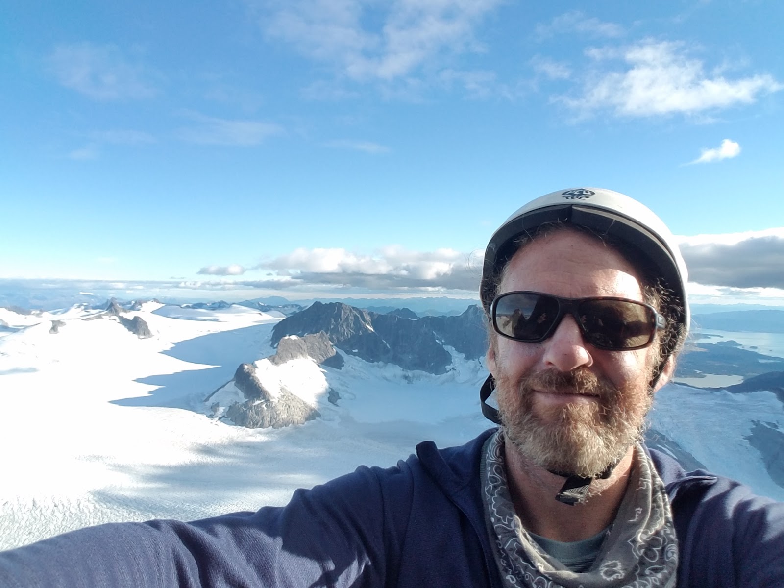
Selfie from the top of Mount 5212 or Pyramid Peak. 
I forgot my crampons, that are never called clampons, and it was a good thing I did even though in the end I never took them out of my pack. Had I brought crampons, we would have pushed out to sea before the waves kicked us off the water. Had we made it to Kasidaya Creek we would had a fighting day trying to muscle our way uphill through a colander made of alders and Devil’s Club. Devil’s Club is the jumping cactus of Alaska. Most likely we would have made it a little way offshore and simply got wet and very cold and returned to Skagway to dry and warm back up.

After climbing Pyramid Peak we made our way slowly back to camp climbing boulders along the way. Once again I wished I had brought my climbing shoes because they are light and bouldering in mountaineering boots is less than optimum.  I have never brought climbing shoes and wished I hadn’t but I often leave my climbing shoes and home and wish I had them. We had a lot of time in the day and it was nice out, regardless of footwear. We got back to the cabin by six and found some people camped nearby. We shared a fire for an hour or so with seven young people that were in Skagway working for the summer.

One of them was the Aleut kid about 20 years old that wants to longboard across North America. Many Aleuts live in Juneau and Angoon. During WWII the military evacuated them from the Aleutian Islands in western Alaska and dropped them at Funter Bay near Juneau to fend for themselves without food or shelter. A third of them died. When the war was over many of the refugees never made it back to the Aleutians. The Aleut I met at the fire spoke Tlingkit but not Aleut. He grew up in the Tlingkit village of Angoon and in Juneau. He told me the Tlingkit word Skagway means "Birthplace of the north wind." No wonder there was smoke on the water.  He didn’t know any of the mountain names in Tlingkit. I wonder if anyone does.

Mount 5,883 is the peak in center. Next time.
We might return to Skagway when the snow is melted out and try again to go through the Gunsight with a rope and gear. The ferry ride was beautiful.  On the way home I thought about the years I lived in Arizona and that I am living in place where snow exists in late May and it isn’t 5,000°F.


Eldred Rock Lighthouse, seen from the ferry.

Thursday, December 29, 2016

The Bears Ears And The Size of Corn Cobs

Corn was smaller a thousand years ago.  This corn cob, minus the corn, has been sitting on the ground for a thousand years or so near a place called Perfect Kiva in the just created Bears Ears National Monument.

President Obama just designated an area in Southern Utah called the Bears Ears National Monument and this ought to be a big deal to climbers because it changes our interaction with some of the most important places we climb. I think most of the changes are for the better. The Bear Ears National Monument will raise many questions that probably should be asked in other places as well. You see the Bear Ears National Monument is home to world class climbing but it was designated because it’s sacred to several tribes and because it contains tens of thousands of archaeological sites. To be clear, climbers aren’t the only ones in love with the land that is now called the Bears Ears and this is bigger than you or me by far.

Sydney climbing the South Six Shooter, April 2014


This designation matters everywhere because climbers' goals and Native American values haven’t always squared in many places. People have climbed cliff dwellings and this has caused irreparable harm.  I recall when a climber trespassed and climbed Spider Rock, a pillar in Canyon de Chelly, Arizona which is considered the home of the Navajo spirit Spider Woman (Na'ashjéii Asdzáá). It’s illegal to climb this sacred pillar. Very few places are banned from climbing for tribal religious reasons and generally tribes are open to climbers. Yet, the climbing community is largely young, full of energy, and sometimes ignorant of the larger picture and differing points of view.  Y’all should know that climbers and musicians are my favorite people. I am not singling anybody out.


Spider Rock (Center), Canyon Chelly, Arizona in 2015
I have been going to the area that is now called the Bears Ears National Monument since I was a toddler. I make regular pilgrimages to Indian Creek. I am originally from Utah and southern Utah was big deal to my family. I thank my folks for making sure we learned the importance of the natural world. At the time we didn’t call it the Bears Ears.  The Bears Ears are actually two buttes that look a little like a bear's ears (if you squint) that are now the namesake for a much larger area that is a 1.4 million acre national monument that includes Indian Creek, Lockhart Basin, Arch/Texas Canyon, Comb Ridge, Valley of the Gods, and countless other climbing locales, some yet to be discovered.  1.4 million acres is a hell of a lot of space.  


Indian Creek,  Utah. April 2014. South and North Six Shooters in the distance.

I think the designation of a new monument is profound for climbers. Yes, I know the lizards in the desert don't know they are monumental now. The landscape itself doesn't have knowledge of legal designations but the designation affects the landscape because laws either protect sites from looting or facilitate it by the spread of roads. Legal designations also determine the extent of oil, gas,and mining development.

Laws governing lands matter.  I think that first that we must band together to continue to protect the Bears Ears. To do this most effectively we have to listen to concerns of people with differing points of view even if they are saying that a particular crag is sacred and ought to be off limits.  The place needs protection because powerful politicians in Utah want to sell it off to oil and gas developers, even though most Utahns approve of the designation.  The Bears Ears need protection because there are huge problems with looting of archaeological sites, including graves.   I think designation means that we as climbers need to step forward and make sacrifices if necessary to protect archaeological sites. We can stay the hell off illegal spires, we can call the police on any looters, and we can provide input on how to stop looting.

Granary in Bullet Canyon, Utah, family reunion 2009
And our input could be quite useful because we are out there with eyes and ears. Looting happens most often where people have easy access by four wheel drives or ATVs and protection of archaeological sites sometimes means closing gates or gating roads altogether and that could mean we have to walk farther to get to our favorite crag. It could mean that some crags will be closed to climbing altogether. The Monument designation could mean new areas open up open because maps will become more robust with greater interest in the area.  Monument designation also means that vast vistas won’t become littered with oil and gas rigs.

These sorts of questions could actually matter even to those that never go to the Bears Ears. No matter where you climb you are climbing in a cultural and geological space that is vastly larger and more complex than your desire to send a new route. Part of the beauty of climbing rock is that it is rich experience that gets richer as you engage different perspectives.  Petroglyphs should be protected everywhere, not just in National Monuments, and they are made of the stuff we climb. So get out there and climb. The rock itself and the history that surrounds it is more beautiful and complex than any one human could ever know.

Sydney, April 2014


Friday, November 18, 2016

The Holy Trinity

Last week I went to Utah. There were a number of reasons for the trip: tickets to Salt Lake City were on special, I wanted to see some sunshine and it’s usually dark and rainy in Juneau in autumn, I wanted to try mountain biking in Moab, I needed a distraction from the fact that many of my neighbors and fellow Americans were bigoted enough to vote for Donald Trump, and other reasons but the prime reason for the trip was that I wanted to meet Tom’s gods.

Moon rising over Deadhorse Point State Park, Utah.

My friend Tom worships the Holy Trinity of bicycle, trail, and desert, most notably mountain biking in and around Moab, Utah. Some people are Baptist, some are Methodists, some are Buddhists, some are Islamists, some are atheists, or some other form of "ist." Tom is a Cyclist, with a capital C, he is also a Moabist, though he lives near Salt Lake City. Tom says he is most happy when the desert is trying to kill him and his favorite desert scene is Moab. I share his love for the area. I have known him for years and yet had never had the opportunity to see his gods in action. In late October I noted airlines special on a night when I was despondent about the extent of racism in America. This was even before it occurred to me that Trump might win. Tom was sending emails and making blog posts about the Slickrock and Captain Ahab Trails with video footage attached.  I needed something like this. I have already spent a good bit of time in Moab and figured a trip back might be in order though in the past my trip were always for rock climbing and canyoneering and never riding bikes.  The last time I rode a mountain bike was over twenty years ago.  As a teen I had a bike and I jumped curbs and sometimes rode trails and dirt roads but mountain biking then and mounting biking now are two entirely different animals.  I went to Utah with some anxiety that I might wreck and make a blood sacrifice to Tom’s gods.

So on a Wednesday evening I flew from Juneau to Seattle and slept in the Alaska Airlines Wing of SeaTac Airport. The following morning, I flew to Salt Lake City and the next day Tom de la Cyclery and I drove to Moab. The drive down is about four hours, ample time to silently stare at the scenery and still have time to talk in depth about things wearing on our minds. In this case we were both thinking about the recent election of Donald Trump. We talked about the fact that before the Clean Water Act and the Clean Air Act, rivers use to light on fire and air pollution has improved in US cities even though the population doubled.  We talked about how Mexican immigration is a shining part of US history, and that black lives really do matter.

Sunset near Moab.
We got to Moab and checked into a cabin in town. We met up with some of Tom’s friends.  Introductions were done and names promptly forgotten. I forgot one of Tom’s friend’s name outright, though I learned later. He thought my name was Hyrum. Yes, we laughed that Carl doesn’t sound one whit like Hyrum but after the laughter subsided I was called Hyrum all weekend. This name is significant because in Utah, Hyrum refers to Hyrum Smith, a prominent polygamist and Joseph Smith’s brother. Jokes were made about multiple wifery all weekend.  The cabin was a great setup partly because Tom and his friends like to bike most of the daylight hours which doesn’t allow time for things like setting tents and other dirty activities. Also, the little cabin was right in Moab which makes it easy to get to restaurants and such.

After we got the keys for the cabin, we went on a ride called Baby Steps in Klondike Bluffs. There is absolutely nothing about this landscape that looks like the actual Klondike in Yukon and I figure I should say this because most of the people reading this actually know what the Yukon is like because they are from Alaska.  The Utah Klondike is a series of bluffs comprised of a mix of bedrock, sand, and boulders. Some of the rocks are whiter than the surrounding red rocks and somehow someone thought it looked like Yukon snow. I suspect peyote drove their thinking.  The “baby steps” are a series of steps in a trail and I don’t think we rode the part of the trail containing the steps themselves. There are many trails in Klondike Bluffs. Any plants in the Utah Klondike are spiny and razor sharp but most of the landscape is pure geology and plants are rare indeed. Looking to the west you see the Island in the Sky part of Canyonlands National Park. It is a spectacular scene and if they ever compromise Canyonlands NP by giving it to the state of Utah, I am going to strangle a host of greedy politicians.


Klondike Bluffs
 On the Klondike Bluffs, I got a feel for the bike and got an understanding of what not to do. On a minor drop I pitched right over the handlebars. I bashed my elbow a little and got up wiser. Lean back a lot when going downhill and take it easy on the front brake.

The next day we ramped up the skill level several notches and rode the Slickrock Trail. This trail is world famous and put Moab on the mountain biking map. It’s arguable that in turn Moab put mountain biking on the map. The Slickrock itself is a rolling maze of Navajo Sandstone with an uncanny ability to grip to bicycle tires. In the midst of this there are vertical chasms that roll off into the abyss. It was named Slickrock because horses and cattle couldn’t get their footing and fell into the canyons. A bike tire, however, sticks to the rock in ways that seem to defy gravity.  I feel I learned a lot about riding on the Slickrock as well and I only crashed twice, both times with little damage.

Our team of riders on the Slickrock.

The following morning, we rode Amasaback, Hymasa, and Captain Ahab trails.  These are three intertwined trails that loop so you can ride them in one loop They are quite steep and unique. Some of the drops were phenomenal and a little crazy. I managed to wreck only once and mistakenly took it as a bad omen that the crash happened only thirty seconds into the ride. I scratched my shin and drew blood.  Blood atonement for Hyrum and the rest of the day went great.

Later that afternoon we rode another trail north of Moab at the Bar M.  It was an easy trail and fun. An odd twist of biking is that steep trails take longer than easy trails because the former need to slow down to clear obstacles like rocks and ravines. We flew through most of the Bar M trail, including a section with banked sweeping S patterns.

Later that evening we went for a moonlight hike at Deadhorse Point State Park. The park offered a ranger led hike and lecture on the occasion of a “super moon,” a full moon that is even larger and brighter than most because the earth and moon are closer together than most full moons. It was a beautiful evening and the moon was indeed bright to the point of not needing flashlights. The downside was the ranger leading the shindig was overwhelmed by about forty people and talked like he normally spoke to small groups of little kids. We left early. We should have just grabbed a six pack and hiked by ourselves out on the Slickrock. Maybe next time. The following morning, we all headed back to Salt Lake area. I spent a day bouldering in the Wasatch foothills, marveling that I went to one of the Meccas of climbing, and didn’t climb and didn’t miss it that much.

Tom’s gods are good gods. They impart sense and reason through means that don’t intuitively make sense. Life’s fears dissipate through the act of embracing something that is actually quite scary. In moments moving through rock and stone at speeds where an accident could cause injury, the human brain isn’t capable of thinking about anything else. It’s impossible to feel guilt for all your sins, perceived or real. It’s impossible to think of greed or anger or hate. For a moment in time, it’s possible to focus only on the wind in your helmet and the feel of rock under your tires. This is true of climbing as well. My next trip to Moab may well be to teach Tom how to climb or to canyoneer. Or to ride bikes again.

Slot Canyon in Utah. 


 As we drove back to Salt Lake City, neither of us were happy about the fact that almost fifty percent of the voters in the US voted for a racist, homophobic, and sexist person, who lies routinely and has zero interest in facts. Yes, climate change is real and it’s not good, homosexual marriage is not a problem for any of us, immigration is not a problem either, but preserving public lands could become a problem, rivers really can light on fire, and air can become even more polluted if we abolish the laws that protect them.  Black lives really do matter. Our bike rides didn’t change the fact that the nation could be headed toward one of those Slickrock chasms without any brakes. However, riding did open my eyes to the notion that all of us with love in our hearts can do something to bring about a better future if we can only keep focused. I rode Captain Ahab and lived.


Back home sitting in my garage there is an old mountain bike with flat tires and a derailleur that slips out of gear. I suppose I should fix it.

Wednesday, September 7, 2016

De ja vous on the Solva Buttress

Labor Day weekend turned out to be 25 ways of awesome and maybe 15 ways of hell. Ryland and I tried to climb the Solva Buttress, also called Fifth Mendenhall Tower. This is the same peak I failed to climb last year about this time. LINK.  I didn’t make it this time either. It’s becoming an obsession.  We left Friday afternoon and took a helicopter up.  We set up camp next to another pair of climbers and chatted with Justin and Colin about how we were going to stay apart enough to not knock rocks onto each other.  Rockfall is a safety concern. We got a plan together that worked.

Ryland with sunset behind him Friday evening.

Colin and Justin started Saturday morning at 5AM and we started at 5:30. They took a wrong turn and we caught up with them. Both Colin and Justin are stronger climbers than Ryland or me. They caught us again later in the day.


Ryland rappelling into the bergschrund

Pitch one went well. Actually all pitches went well but they went too slowly for us to make the top.  It was at the top of pitch 8 that we figured it was time to turn back, at about 5PM. The Solva Buttress is 11 pitches and about 1,600 feet of prominence, at least as described by Mountain Project. The exact start/end of pitches varies from climbing team to climbing team on a trad climb. Traditional climbing (called trad) involves placing cams into cracks in the rocks which are used as anchors in the event of a fall.  We climbed about 1,200 feet in our eight pitches.  The last 400 feet are for next year.  Our descent was slow and fraught with problems and we didn’t make it back to camp until 3:30 AM.


Pitch one
It was awesome in its sublime beauty and it wasn’t sublime solely aesthetically.  The nunataks of the Juneau Icefield are remnants of the Pleistocene. The ice age never stopped up there.  A nunatak is and island only the water is glacial. Juneau Icefield nunataks are chuncks of granite jutting into the sky. The  Mendenhall Towers are a single nunatak with seven spires jutting thousands of feet above the Juneau Icefield.  The sheer scale of the peaks and ice is boggling. Further, the struggle of a big wall is both physical and mental, regardless of the setting. This was a big deal, at least for me.  The northern lights pranced around the sky like mad horses while we slept, or tried to sleep, outside Friday night. While the aurora danced, the wind picked up and I damn near froze.

Before we even started pitch one, we had to climb over the bergschrund, a gap between the rock wall and the glacier, like a crevasse only with rock on one side. Ultimately, we decided to dig a hole in the snow on the glacier side and bury an axe with a tether to use as an anchor. This type of anchor is called a dead-man.  We rappelled off the dead-man and into the bergschrund and climbed back up onto the rock. It was likely the shortest rappel I have ever done but this bergstrund scares me.  If you slip in the bergschrund and you are not on belay, you may slide under the glacier and never be seen again. Once on the rock itself I noticed I had forgotten my climbing shoes and had to retrace my steps and get them at camp. By and by we got started. Pitch one is one of the harder pitches of the day but it’s easier because it’s pitch one.  As we reached the top of pitch one, we could hear Colin and Justin off to the side talking to and fro and trying to figure their way back on route. They turned cross mountain too early to get onto pitch two. Ryland led pitch 2 and got a little turned himself but he retraced his steps and made it back on route.  Justin and Colin got back on route by some tricky climbing that combined pitches 2 and 3 and met us at the bottom of pitch 4.

Looking down from Pitch one. The glacier is cracked into a labyrinth of broken glass all the way from the Mendenhall Towers to town, which is why most folks take a helicopter rather than walk.


 Justin and Colin's Camp, Sunrise 
It became clear at this point that even though they made a wrong turn, Justin and Colin were much faster than Ryland and I.  Because I am a little faster at setting trad, I started leading every pitch after pitch 2 and placed all the cams.  Ryland followed and cleaned them. We seemed to be too slow at exchanging the gear and other stuff you do between the end of one pitch and the start of climbing the next.

We continued up the wall all day and did indeed have lunch with Justin and Colin around 1:30 at the top of pitch 5. Ryland and I were slow but we were learning and getting quicker. We ate bagels with smoked salmon.  We ate brownies with coffee in em.  Good stuff.

One of the things that made this trip worth doing for me was the large improvement in my skills at trad. I seriously think I moved up a whole grade in what I am comfortable with while climbing trad. One must be a climber to know how incredible that is. It will take me years to make a jump to another grade. The learning curve is steeper at first and I climbed the learning curve this trip. We didn't make the summit but we learned a lot about climbing, particularly this type of climbing. I smile days later just thinking about that.

View from top of pitch 8 


Note the shadow of Mount Wrather is not only beautiful but an indication that it's getting too late to continue uphill. 
As we headed to the top of pitch seven I started to see concerning signs of exhaustion.  Ryland started falling more often. This wasn’t a safety concern  as he was still getting up the wall and the consequences of a fall while following and cleaning are minor.  Yet, it was clear he was getting tired to the point where fuckups happen and I was tired as well. Ryland joked that he was delirious but his joke sounded just a little delirious.  I was concerned because the consequences of a fall while leading can be larger and I was feeling pretty worked. If you slip while you are ten feet above your last cam, you fall twenty feet before the rope catches you. A whipper is a smaller situation when you aren't high on a wall.  It didn't help that the most painful whipper I have taken was on this very wall. At the top of pitch 8 there is a ledge with a spectacular view and we got there about 5. In early September, it’s dark by 9.

Ryland, near top of pitch seven.


 Fourth Tower as seen from top of pitch 8
We chatted options and Ryland suggested that we keep going and call the helicopter company and see if they could pick us up from the summit.  It sounded great to me except that pitch 9 is the hardest climb on the tower and I felt my skills were stretched at the moment so I told Ryland that pitch 9 was beyond my skill level. Looking back and after talking to Justin and Colin, I think I could do it. Next year we may test that hypothesis.

 If you get stuck on a wall in the dark, you have two reasonable choices. Stop and wait until it’s light or continue on at a snail’s pace. Once it's dark moving quickly isn't an option.We started rappelling down and each rappel we had to fight stuck ropes.  We had both run out of water and it was going to get real cold at that elevation so we opted for the snail’s pace.  We had to move super slow because we had to anchor into the wall at every juncture and we had to check each move three times. We finally got down to the damn bergschrund around 2:30 and it was a fucking struggle to get our gear back up the fifteen-foot drop. It was one of the hardest physical things I have ever done. About that time, it started to rain. Could be worse, it could be raining.  That or we could be in the bottom of a bergschrund in the middle of the night on hour twenty.

At 3:30 AM we climbed into our tent, drank a bunch of water and downed a beer and fell asleep. Even with my wet clothes removed I was clammy in the sleeping bag.  That night both my legs cramped badly. It took me five minutes to put on my boots in the morning because I simply couldn’t lift my legs without cramping. One particular cramp, my right calf muscle moved two inches toward my Achilles tendon and balled up like an egg.  In the aftermath I wish I had taken a photo of my freak show my calf muscle became but I was too busy cursing to think about it at the time. At 8:30AM we got picked up by the heli. It had quit raining and the sun was out like nothing ever happened. 

Mountains are like that; completely indifferent to us. They aren't there to entertain us or kill us or make us feel small or inspire us to understand God. They don't give two shits about us one way or another. If we fall to our deaths, they continue to be rocks standing in icefields. If we get to top, they continue to be rocks in icefields.

We are meaningless to mountains. That's part of their appeal, at least to me.

View of gap between Solva Buttress and Tower 6 looking into the Juneau icefield north.


I feel like I dreamed some of this trip. It was too cool for words. It also had moments that the dream felt like a nightmare.  When I got back to the heliport, I had lost the keys to my truck. I spread out everything I owned on the parking lot of Coastal Helicopters and still didn’t find them. Evonne brought me a spare set and I packed  up my gear from all over the road and went home. By and by I found them in my first aid kit and can only guess how they got there.


Our camp.

Monday, July 25, 2016

Mermaids and Witches Along The Pirate Shore

Most folks that know me know I have been working to develop places to climb around Juneau. see LINK.  This post is about some great work, though not done by me.  

Greek legend speaks of Ulysses and his sailors approaching a rocky shore with sirens (mermaids) singing. The bAeauty of the sirens and the beauty of their voices called the sailors into the rocks and to their deaths. The sailors knew they would die and yet they could not resist and this is why the story resonates now, two thousand years later and will still resonate two thousand years from now. It goes without saying that Homer had his shit together. He captured the human desire to risk it all for beauty, love, or rocks so well.  


Pete Boyd kayaking along the Pirate Shore at low tide. MerWitch Cliff in background.

There is a rocky nameless stretch of shore north of Juneau that I call the Pirate Shore. I call it that because it’s a mouthful to say “the rocky shore between the Peterson Creek salt-chuck and Boy Scout Beach,”  and because this summer it was extensively surveyed for climbing by the pirate Ammon Mcneely.  Ammon took time off from climbing big walls to work as a guide in Juneau this summer. In his spare time he spent many, many hours exploring, cleaning, and mapping out cliffs along the shore. 

Brett climbing a V1 on Stowaway Boulder.


Ammon Mcneely, Stowaway Boulder

Displaying 20160801_175752.jpg

Ammon hiked down to the beach from where he lives for the view and because phone service is better there. Because Ammon is a climber he looked for rocks to climb. That's what climbers do. Pretty soon he was cleaning the Stowaway Boulder. It's a little boulder with a nice V1 and a V3-4 so far. There is more to do on the Stowaway. Ammon calls it his sanctuary as it's in a little niche off the beach. Early in the summer he found the Merwitch Cliff and cleaned a couple routes there as well. This time frame more or less coincides with when he contacted me at the Juneau Alpine Club about wanting to climb with us while he is here for the summer. 


Kevin Walsh rappelling MerWitch Cliff. Seen from the south. 

Since Ammon told me about this place, people have been going out there both solo and with Ammon and checking stuff out.  You can get to MerWitch and to Stowaway Boulder without a kayak but the rest of the Pirate Shore is a major bushwhack to access on foot as yet.  You could indeed stash treasure along the shore.  
MerWitch Cliff as seen from the north. 

It’s going to be fun to develop these cliffs. So far I have only seen and photographed the MerWitch Cliff, Stowaway Boulder, and the Siren's Wall but there are other walls tucked away along the shore and up the hill. Treasure. The rock is solid, they are close enough to town to get out there in the evening, and the view is knockout. Ammon named the furthest south cliff south the MerWitch Cliff because moss hangs like witch’s hair from the trees above and the sea below beckons mermaids. 


Most of Southeast Alaska feels like that; like elements of the natural world could become animated and speak. If I believed in ghosts, angels, or demons, I think they would like it here. 


I want to fall in ocean, Ensconced in the sound,

Abandon all hope, 
Surrender and drown.
All that I want are sirens...
I want to hear them sing 

Map. You get to Stowaway by turning left after the bridge at EVC. Merwitch is right. Follow the trail to the kayak beach and continue past. The trail fades and eventually disappears. Then rock hop around the shore to until you see MerWitch.

The Siren's Wall is further north and up in the woods from the beach. With some trailblazing it could be easily accessed from Boy Scout Beach. There are many cliffs tucked all over the place out there and some trail work might be in order. The Siren's Wall is quite extensive and about 100 feet tall. Right now it's a short but gnarly bushwhack up to this thing. it's sort of a semivertical slimefield actually. Yet, the climbing could be really good and the path improved with a few hand lines up there. It's a short distance up, the rock is solid, and Ammon has already done some work. 


Part of why I am writing this is so people can help him get some of this stuff done.


Ammon, Siren's Wall behind. It wraps around to the right with a lot of routes.


Looking west from MerWitch Cliff. A storm is coming.


The bigger picture is the fact that Ammon found these cliffs indicates that we can find a lot more places to climb and that the rocks of Juneau are not all choss and slate. Kevin Walsh, a geologist and climber, told me that Juneau’s rock strata were formed by several episodes of geological uplift from islands colliding with the main tectonic plate that left a mishmash of rock types that is both understudied and highly complex. Rock types differ within a very small area and from a climbers' perspective that means high quality rock exists in pockets that can be adjacent to choss and vice versa.  One must look to find and it seems the best options to look more closely are north of town.  

Ammon clearing brush near Siren's Wall.


An as yet un-visited cliff about 500 feet up a hill north of MerWitch and east of Siren's Wall (Below). I used a zoom lens as it is about a half mile from MerWitch. 


Note the eagle in the foreground has zero interest in rock climbing, witches, or mermaids. It's probably better off. Falling in love with sirens can get you in trouble. So can climbing..